Central Springs/East Coast Regional Water Supply Plan (CSEC RWSP)
- Overview
- CSEC RWSP
- Meetings
- Central Springs Model
- Southern District Density – Dependent Model
- Minimum flows and levels (MFLs)
- Water conservation
Mission:
Protection of natural resources and cost-effective, sustainable water supplies in the Central Springs/East Coast region of the St. Johns River Water Management District through collaborative planning, scientific-tool development and project implementation.
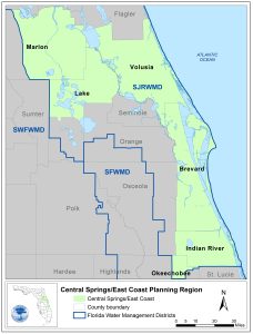 The Central Springs/East Coast (CSEC) Regional Water Supply Plan (RWSP) area includes all or part of six counties in the St. Johns River Water Management District — Volusia, northern Lake, Marion, Brevard (excluding the city of Cocoa service area, which is included in the Central Florida Water Initiative), Indian River, and Okeechobee counties. The northern portion of the planning region is home to six of the eight Outstanding Florida Springs in the District including Silver and Silver Glen in Marion County, Alexander in Lake County, and Volusia Blue, DeLeon, and Gemini in Volusia County. The CSEC planning region features the headwaters of the St. Johns River, the Indian River Lagoon and more than 140 miles of Atlantic coastline.
The District conducts water supply planning in collaboration with local governments, public supply utilities, environmental advocates, neighboring water management districts, and other stakeholders for a 20-year planning period. Based on the best data and research available at the time of plan development, the 2022 CSEC RWSP indicated that fresh groundwater alone could not supply the projected increase in water demand in 2040 without causing unacceptable harm to water resources. The plan identified solutions, including water supply and water resource development projects and water conservation potential, to meet future needs while protecting the region’s natural resources.
Preparation of the 2027 five-year update to the CSEC RWSP is currently underway. This update will evaluate projected water demand extending to the 2050 planning horizon. New groundwater models will be utilized in the CSEC water resource assessment. The Central Springs Groundwater Flow Model version 1.1 (CSM v1.1) will replace the Northern District Model version 5 (NDMv5) and the Volusia Groundwater Flow Model that were used in the 2022 plan. In addition, the Southern District Density Dependent Groundwater Flow and Transport Model (S3DM) will allow for predictive water quality scenarios in areas of the planning region where saltwater intrusion is a concern. An effort to update several minimum flows and levels (MFLs) lake surface water models will yield revised compliance assessments that will be integrated into the water resource assessment, in addition to any new or re-evaluated MFLs. These tools and others will help to assess whether available water supplies can meet the demands of the CSEC region without causing unacceptable harm to water resources.
Sign up to receive information about the CSEC RWSP by email.
2027 CSEC RWSP development progress
Note: Timeframes below are estimates and subject to change
- Initial outreach to municipal utilities (COMPLETE)
- Release of draft 2050 water demand projections (COMPLETE, click HERE)
- Release of draft 2050 demand geodatabases for groundwater model well file development (fall 2025)
- Technical methods workshop (early 2026)
- Project solicitation (summer 2026)
- Release of draft 2027 CSEC RWSP (early 2027)
- Public workshops (early 2027)
- Presentation of 2027 CSEC RWSP to SJRWMD Governing Board (fall 2027)
Contact
Joy Kokjohn
Regional Water Supply Planning Coordinator
386-329-4223
2027 CSEC RWSP – draft documents and files
Draft 2020 – 2050 population and water demand projections (10/17/25)
Note: District staff are actively reviewing feedback received on the 8/26/25 draft public supply projections, and therefore, the 10/17/25 version of the draft projections does not address all received comments. A revised version will be posted upon completion of the public supply review.
Please submit any comments on the draft projections to Joy Kokjohn at jkokjohn@sjrwmd.com.
- Draft public supply population and water demand projections (8/26/25)
2022 CSEC RWSP
The 2022 Central Springs/East Coast Regional Water Supply Plan and associated appendices were approved by the Governing Board on February 8, 2022.
2026 Meetings and Associated Documents (coming soon)
Archive
2022 Meetings and Associated Documents
SJRWMD Governing Board Meeting
Tuesday, February 8, 2022
District Governing Board Room, 4049 Reid Street, Palatka, FL 32177
2021 Meetings and Associated Documents
Technical Methods Workshop
Wednesday, July 21, 2021 at 5:05 pm
District Governing Board Room, 4049 Reid Street, Palatka, FL 32177
RWSP workshops
The District held three public workshops to communicate the status, overall conceptual intent, and impacts of the Central Springs/East Coast Regional Water Supply Plan on existing and future reasonable-beneficial uses and related natural systems. Each workshop presented the same overall summary for the planning region. In addition, specific details pertaining to the sub-region in which the workshop was held (1 – Volusia County, 2 – Brevard, Indian River, and Okeechobee counties, and 3 – Marion and northern Lake counties) was presented.
Workshop 1 (Volusia County)
Monday July 26, 2021 at 5:30 pm
Frank T. Bruno, Jr. County Council Chambers (Room 204), Thomas C. Kelly Administration Center, 123 West Indiana Avenue, DeLand, FL 32720
Workshop 2 (Brevard, Indian River, and Okeechobee counties)
Wednesday, July 28, 2021 at 5:30 pm
Commission Chambers, Indian River County Administrative Complex, 1801 27th Street, Building A, Vero Beach, FL 32960
Workshop 3 (Marion and northern Lake counties)
Thursday, July 29, 2021 at 5:30 p.m.
Board of County Commissioners Chambers (2nd floor), Lake County Administration Building, 315 West Main Street, Tavares, FL 32778
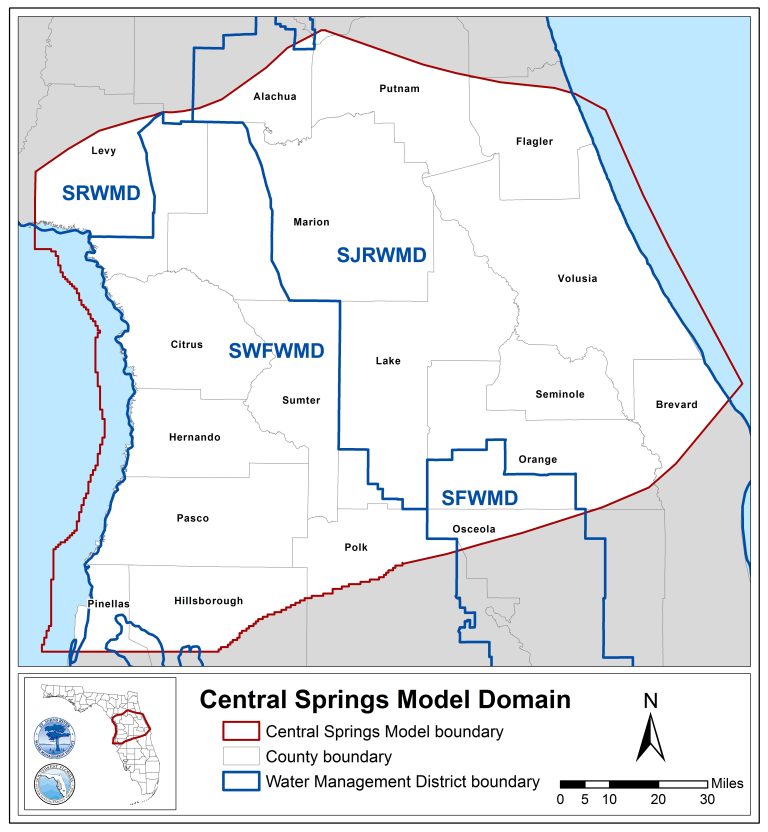
The Central Springs Groundwater Flow Model (CSM) is a groundwater model developed collaboratively by a technical team of groundwater modelers and professionals at the St. Johns River Water Management District (SJRWMD) and the Southwest Florida Water Management District (SWFWMD). The CSM was designed to quantify the effects of current and future groundwater withdrawals on the water resources within the model domain. The CSM technical team successfully developed a technically defensible groundwater model using sound science and generally accepted standards for groundwater model development. The CSM effectively represents regional hydrologic conditions within the model domain and simulates the spatial and temporal variations of aquifer levels, spring flows, and river baseflows in north-central Florida.
The CSM version 1.0 (v1.0) was reviewed by independent modeling experts (peer reviewers) and interested stakeholders and was finalized in early 2024. Upon completion of CSM v1.0, the CSM development team immediately began working on an improved version of the model (v1.1). The CSM v1.1 addressed specific peer review comments and stakeholder comments received for CSM v1.0. In the SJRWMD, the CSM v1.1 will be used for water supply planning, minimum flow and levels (MFLs) development, and consumptive use permitting. In the SWFWMD, the CSM v1.1 will be utilized for MFL development and for groundwater evaluations previously performed with the Northern District Model for larger quantity permits to assess potential adverse impacts to springs.
CSM v1.1 Final Report and Model Files
- Final Report
- Model Files (command line and Groundwater Vistas)
- CSM v1.1 Regulatory Tool and Memo (April 2025)
IMPORTANT – Prior to using the CSM Regulatory Tool, please check with district regulatory staff at the number below to confirm that this model is appropriate for your project. The CSM Regulatory Tool will be updated regularly. Please ensure use of the latest version (posted above).
- SJRWMD Permitting Customer Service – (386) 329-4570
- SWFWMD Water Use Permit Bureau, Dalton Weinstein – (813) 467-7786
CSM v1.0 Final Report, Model Files, and Documentation
- Final Report
- Model Files (command line and Groundwater Vistas)
- Peer Review Comment Responses
- Stakeholder Comment Responses
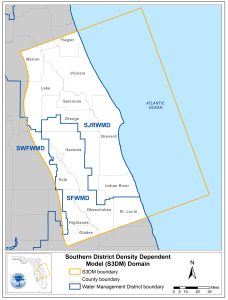 Groundwater quality, mainly along coastal communities, has been degraded in some parts of Florida primarily due to saltwater intrusion resulting from increased groundwater withdrawals. In addition, sea-level rise and other aspects of climate change have the potential to exacerbate this problem. Thus, the District and its contractors are developing the Southern District Density-Dependent Groundwater Flow and Transport Model (S3DM) which will be utilized to evaluate the effects of pumping and sea level rise on water quality associated with saltwater intrusion in the coastal portion of the CSEC planning region. Once complete, the S3DM model files and associated documentation will be posted here.
The CSEC planning region includes 54 water bodies with adopted minimum flows and levels (MFLs); 42 lakes, two rivers (three reaches), eight springs, and one water management area. There are also several water bodies in the CSEC region that are currently on the MFLs Priority List and Schedule; Lake Weir in Marion County for MFLs re-evaluation in 2026 and the Upper Ocklawaha River Basin lakes for new MFLs development in 2027. In addition, District staff are working to create new surface water models or statistical models for several existing MFL lakes in the region, which will be utilized in the water resource assessment for the 2027 CSEC RWSP.
Click here for more information on SJRWMD MFLs.
MFLs Prevention/Recovery Strategies
There are three approved MFLs prevention/recovery strategies within the CSEC planning region. The Prevention/Recovery Strategy for Implementation of Minimum Flows and Levels for Volusia Blue Spring and Big, Daugharty, Helen, Hires, Indian, and Three Island Lake (2013 Volusia Strategy) was approved by the District Governing Board on November 12, 2013. In 2018, the first five-year strategy assessment was performed to ensure the continued success of the Volusia Strategy through 2040. The Prevention Strategy for the Implementation of Silver Springs Minimum Flows and Levels was approved by the SJRWMD Governing Board on April 11, 2017. Finally, the Prevention Strategy for the Implementation of Lake Butler Minimum Levels was approved by the Governing Board on August 11, 2020.
Click here to review the strategy documents.
Simple, economical water conservation is vital to protecting Florida’s water resources and natural ecosystems, especially as population growth drives increased demand. Water conservation is a fundamental pillar of water supply planning for many reasons, including:
- Demand management – By reducing unnecessary water usage, water conservation helps align water consumption with available supplies.
- Sustainability – Water conservation promotes the long-term sustainability of water resources and ensures a supply for future generations.
- Cost-effectiveness – Water conservation is often more cost-effective than developing new water supply sources. Building new reservoirs, treatment plants, and pipelines requires significant and long-term financial commitments.
- Environmental protection – Water conservation helps to protect natural ecosystems by reducing the strain on rivers, lakes, and aquifers.
Water conservation is not just an environmentally sound practice, it’s a strategically vital component of ensuring reliable and sustainable water supplies. For this reason, the CSEC RWSP seeks to engage its water users and challenge them to identify ways to lower water usage and conserve.
Find additional information on water conservation on the following websites:

